
The I-95 EV Corridor: Boston to Miami
Last updated: July 23, 2026
I-95 from Boston to Miami runs roughly 1,500 miles through more than a dozen states, and it is the most heavily traveled long-distance EV corridor on the East Coast. As of mid-2026 it is also one of the easiest interstates in the country to drive electric: Tesla Superchargers, Electrify America, EVgo, ChargePoint, and newer travel-center networks such as BP Pulse and IONNA all have sites along it, and most stretches put a DC fast charger within reach every 50 miles or so.
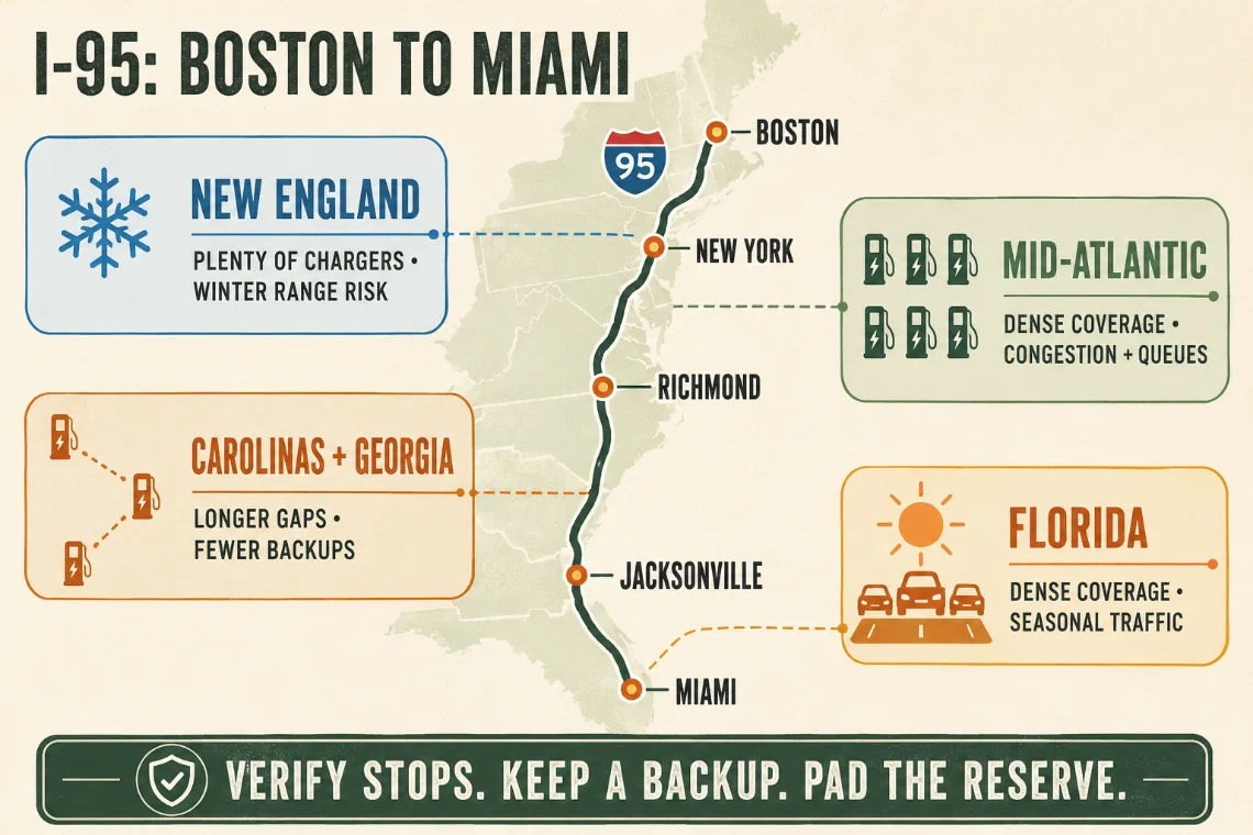
That said, the corridor is not uniform. It breaks into four regions with distinct characters, and the failure modes change as you go: cold in the north, congestion in the middle, distance in the south. Here is what to expect region by region, and how to plan around it.
New England: Boston to the New York line
The Boston–Providence–New Haven stretch is short on distance and long on chargers. Sites cluster around the cities and along Connecticut's shoreline, and even mid-size exits usually have a fast-charging option within a few miles. Coverage is rarely the problem here.
Winter is. Cold snaps in New England commonly cut real-world range 20 to 30 percent, and highway speeds make it worse. EVLONGHAUL applies a flat 8 percent buffer to your EPA rated range in every season, but it has no weather model, so in January that buffer alone is not enough. Raise your minimum arrival charge, plan shorter legs, and read the winter range guide before a cold-month run through this region.
The mid-Atlantic metro chain: New York to Richmond
From the New York area through New Jersey, Delaware, Maryland, D.C., and down to Richmond, I-95 is a chain of metros with the densest (and busiest) charging on the corridor. The New Jersey Turnpike and the Delaware and Maryland service plazas have fast-charging hubs directly on the toll road, which is convenient but makes them the first places to queue when traffic peaks.
The saving grace is redundancy. If a plaza site is full or partly down, there is almost always another network a few miles off the next exit. This is where EVLONGHAUL's itinerary earns its keep: each stop lists how far it sits off your route, and the route line itself bends out to every charger, so you can see at a glance whether a stop costs you five minutes or thirty.
The Carolinas and Georgia: the gap that mostly closed
For years this was the corridor's weak stretch. Between Richmond and Jacksonville, I-95 mostly bypasses big cities and runs through long rural sections past towns like Fayetteville, Florence, Santee, and Walterboro. Tesla covered it early; drivers on CCS often faced spacings of 40 to 60 miles between usable fast chargers, sometimes depending on a single site with a handful of stalls.
That picture has improved substantially. Travel-center hubs, network expansion, and state buildout (South Carolina, for one, put I-95 in the first phase of its federal charging plan) have filled in most of the distance gaps. Still, treat this region with more respect than the Northeast: sites are farther apart, backups are fewer, and one full or offline station matters more. Keep a larger reserve, and verify your planned stop's status in a charging app before you commit to it, because EVLONGHAUL works from public station data, not live availability.
Florida: dense, but seasonal
Once you cross into Florida, density returns. The Jacksonville-to-Miami run passes through a nearly continuous string of coastal metros, and Florida ranks among the top states in the country for both EV registrations and public charging. On paper, this is the easiest quarter of the trip.
In practice, timing matters. Snowbird migration pushes heavy southbound traffic roughly October through December and heavy northbound traffic in March and April, and the same interstate sites everyone's route planner suggests are the ones that back up. Charging a little earlier or later than the obvious stop, or one exit off the main cluster, often skips the line entirely.
What the NEVI buildout added
The federal National Electric Vehicle Infrastructure (NEVI) program funds fast-charging sites along designated corridors: the target is stations no more than 50 miles apart, each with at least four 150 kW ports. I-95 is a designated corridor for its entire length, and NEVI money is a big part of why the rural Southeast gaps closed.
The program's history is messy: federal funding was frozen in early 2025, a court injunction in June 2025 pried it back open, revised federal guidance that August let states resubmit their plans, and a final court judgment in January 2026 barred the government from withholding the funds again. Pennsylvania has been among the fastest to open NEVI-funded sites, and more are opening along the Eastern Seaboard through 2026. The practical takeaway: coverage is a moving target, and any map, including a planned trip, is a snapshot. The U.S. DOE's Alternative Fuels Data Center, which supplies EVLONGHAUL's station data, is updated regularly, but always confirm a station exists and is operating before you depend on it.
Practical corridor tips
- Charge before city bypasses. Top up before the Capital Beltway, the New Jersey Turnpike splits, and the I-295 loop at Jacksonville. Hunting for a charger in metro traffic is the worst version of this trip.
- Skip the most obvious sites at peak times. Around Thanksgiving, Christmas, and snowbird season, on-plaza and first-exit chargers queue first. A site a few miles farther along is often empty.
- Filter for speed where you can. The corridor has plenty of 150 kW+ hardware; using EVLONGHAUL's 150 kW+ filter keeps stops short. The planner already prefers 100 kW+ stations when placing stops. The methodology guide explains how.
- Know your connector situation. Many Superchargers along I-95 now serve non-Tesla EVs with a native NACS port or an approved adapter, but access varies by site and by model. Sort this out before the trip. See CCS vs. NACS.
- Pad the buffer where it counts. Winter north of New York, rural stretches south of Richmond. An extra 10 percent of arrival charge is cheap insurance.
- Expect a wide pricing spread. A dozen networks operate along this corridor and per-kWh rates vary between them and from state to state, so the same kWh can cost noticeably more in one plaza than the next. What road-trip charging really costs covers typical rates, idle fees, and which memberships pay for themselves on a run this long.
Plan the trip in the EVLONGHAUL planner with your actual vehicle, starting charge, and connector, and it will space real stations along the route for you. Then double-check the handful of stops it picks. Estimates get you organized; verification gets you there. For the same exercise on an inland route with the opposite problem, thinner rural spacing rather than crowded plazas, see Chicago to Atlanta in an EV.