
Chicago to Atlanta in an EV
Last updated: August 24, 2026
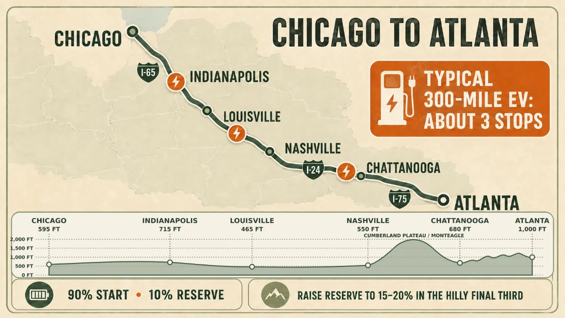
Chicago to Atlanta is EVLONGHAUL's default trip for a reason. At roughly 720 miles down I-65, I-24, and I-75, it is long enough to force real charging decisions but short enough to finish in one very long day. The route runs through Indianapolis, Louisville, Nashville, and Chattanooga: a corridor where fast charging is generally in good shape, with a few stretches worth thinking about before you leave.
The route at a glance
I-65 carries you south out of Chicago through Indianapolis and Louisville to Nashville. I-24 takes over for the run southeast across the Cumberland Plateau to Chattanooga, and I-75 finishes the job into Atlanta. Plan on 11 to 12 hours of driving before you add charging time and traffic. And Chicago at the start and Atlanta at the end are both places you do not want to hit at rush hour.
Gas-car guides treat this as a one-fuel-stop day. In a typical EV it becomes a two-to-three-stop day, and where those stops land depends more on your car and your settings than on the map.
What a 300-mile EV actually needs
EVLONGHAUL starts from your car's EPA rating and applies a flat 8% buffer for highway speeds and weather, so a 300-mile car plans as about 276 usable miles. The first leg budgets your starting charge minus your arrival reserve; every later leg assumes you charge to 80% at each stop and budgets from there. The full method is laid out in how we plan charge stops.
With a 90% starting charge and a 10% arrival reserve, the arithmetic looks like this:
- First leg: about 220 miles. The first stop typically lands in central Indiana, around the Indianapolis area.
- Later legs: about 195 miles each. A second stop tends to fall in south-central Kentucky, and a third in southeast Tennessee near Chattanooga, leaving an easy final run into Atlanta.
That is three stops, not two, for a true 300-mile car with everyday settings. A car rated around 350 miles can squeeze the trip into two stops if it leaves at 100%. With the everyday settings above, even that car comes up about a dozen miles short of a two-stop day. Each stop's time estimate assumes you add about 60% of the pack at an average rate well below the charger's peak (fast charging tapers as the battery fills), which for a typical mid-size pack works out to roughly half an hour on 150 kW-class hardware. Three fast-charging stops is also most of what the drive costs you at the plug; what road-trip charging really costs works through typical per-kWh rates and how they compare with a 30 mpg gas car.
Coverage: strong in the cities, thinner between them
The metro areas on this route (Indianapolis, Louisville, Nashville, Chattanooga, and especially Atlanta) all have healthy clusters of DC fast charging. Tennessee has also been filling corridor gaps through a state fast-charging program aimed at regular spacing along its interstates, so the middle of this trip has improved noticeably over the past few years. Corridor coverage differs sharply by region: the I-95 EV corridor is denser but far busier, which makes queueing, rather than spacing, the problem to plan around.
The stretches to watch are the rural runs between metros: I-65 across southern Indiana and central Kentucky, and I-24 over the plateau between Nashville and Chattanooga. Stations exist, but they are spaced further apart, and a broken charger costs more when the next option may be 40 miles down the road. Two habits help:
- Watch the pin colors and the line. Pin color shows charging speed (green for 250 kW+, orange for 100–249 kW, dark for slower or unlisted hardware), and the route line itself detours to each stop, so a charger well off the interstate is visible as a real dogleg in your drive, with its off-route miles listed on the itinerary entry. A dashed "?" pin means the planner found nothing that fit and is marking a suggested charge area rather than inventing a station.
- Verify before you rely on it. EVLONGHAUL plans from public station data and has no live status or availability. Before you commit to a sparse stretch, check the stations you are counting on in your charging network's app or the AFDC station locator.
Terrain shifts the math south of Nashville
The first 450 miles are flat to gently rolling: Indiana farmland and Kentucky hills that barely register in your consumption. South of Nashville the picture changes. I-24 climbs the Cumberland Plateau, including the long Monteagle grade, then drops into the Tennessee River valley at Chattanooga, and I-75 rolls through the north Georgia hills the rest of the way.
EVLONGHAUL has no elevation model; the 8% buffer is its whole cushion for terrain, speed, and weather combined. Sustained grades at interstate speed can eat into that, so a sensible adjustment for this trip is a higher arrival reserve on the hilly final third: plan to arrive at 15–20% rather than 10%. Cold weather stacks its own penalty on top of terrain, so leave even more margin if you are making this drive in winter.
Settings that change the plan
Run the same trip with different settings and watch the stops move:
- Starting charge. Every 10% of charge is roughly 28 miles for a 300-mile car. Leave at 100% and the first stop pushes past Indianapolis; leave at 70% and it slides well north of the city.
- Arrival reserve. Raising it from 10% to 20% shortens every leg by about the same 28 miles, which can add a stop to the day. On this route that trade often makes sense: the margin matters most exactly where stations thin out and the grades begin.
- Charger speed. Filtering to 150 kW and up leaves fewer candidate stations but shorter stops. On the metro segments that filter is usually affordable; through rural Kentucky and the plateau, the wider "any DC fast" setting keeps more options in play. Either way, the planner prefers 100 kW+ hardware when placing a stop.
- Connector and network. As of mid-2026 the NACS transition is still in its messy middle: many non-Tesla drivers fast-charge through an adapter, and access varies by brand and model year. Set the connector your car can actually use (see CCS vs. NACS), and if you prefer one network, EVLONGHAUL compares up to three alternate routes and favors the one that keeps the most stops on it.
Run it with your own car
The numbers above describe a generic 300-mile EV. Your car is not generic. Open the planner (this trip loads by default) and pick your year, make, and model from the EPA catalog of more than 1,500 battery-electric vehicles. Where EPA does not publish a battery size, the planner estimates one and marks it with a "≈" so you know it is derived rather than official. Then nudge the settings: starting charge, arrival reserve, connector, charger speed. Watching the stops shuffle is the fastest way to build intuition for what your car needs on this corridor.
These are planning estimates, not promises. Confirm charger status the morning you leave, keep a fallback in mind for the sparse stretches, and run through the EV road trip checklist before you pull out of the driveway.